文章信息:Miao Yang, Chen Ren, Haorui Wang, Junqi Wang, Zhuangbo Feng, Prashant Kumar, Fariborz Haghighat, & Shi-Jie Cao. (2024). Mitigating urban heat island through neighboring rural land cover. Nature Cities, 1(1), 522–532. https://doi.org/10.1038/s44284-024-00091-z
整理人:闫甲祺,2024级硕士研究生
整理时间:2025年3月20日
Abstract: Globally, the deteriorating Urban Heat Island (UHI) effect poses a significant threat to human health and undermines ecosystem stability. UHI mitigation strategies have been investigated and utilized extensively within cities by the provision of green, blue or gray infrastructures. However, urban land is precious and limited for these interventions, making it challenging to address this issue. Neighboring rural land cover may serve as a cooling source and have a great potential to mitigate UHI through processes such as heat absorption and circulation. This study aims to address the following questions: (1) what is the location of neighboring rural land cover to effectively mitigate UHI for the entire city and (2) what are the key parameters of the landscape. We investigated the quantitative and qualitative relationships between rural land cover and UHI, drawing on geographical and environmental data from 30 Chinese cities between 2000 and 2020. We found that the rural land cover extending outward from the urban boundary, approximately half of the equivalent diameter of city, had the most pronounced impact on UHI mitigation. The number and adjacency of landscape patches (a patch is a homogeneous and nonlinear basic unit of a landscape pattern, distinct from its surroundings) emerged as two key factors in mitigating UHI, with their individual potential to reduce UHI by up to 0.5 °C. The proposed recommendations were to avoid fragmentation and enhance shape complexity and distribution uniformity of patches. This work opens new avenues for addressing high-temperature urban catastrophes from a rural perspective, which may also promote coordinated development between urban and rural areas.
摘要:在全球范围内,不断恶化的城市热岛效应对人类健康构成重大威胁,并破坏生态系统的稳定性。通过提供绿色、蓝色或灰色基础设施,UHI 缓解策略已在城市内得到研究和广泛使用。然而,城市土地非常宝贵且有限,无法进行这些干预,这使得解决这个问题具有挑战性。邻近的农村土地覆盖物可以作为冷却源,并且具有通过吸热和循环等过程缓解 UHI 的巨大潜力。本研究旨在解决以下问题:(1) 有效缓解整个城市的 UHI 的邻近农村土地覆盖的位置是什么,以及 (2) 景观的关键参数是什么。我们利用 2000 年至 2020 年间中国 30 个城市的地理和环境数据,调查了农村土地覆盖与 UHI 之间的定量和定性关系。我们发现,从城市边界向外延伸的农村土地覆盖,大约是城市等效直径的一半,对 UHI 缓解的影响最为明显。景观斑块的数量和相邻性(斑块是景观模式的同质和非线性基本单位,与周围环境不同)成为减轻 UHI 的两个关键因素,它们各自有可能将 UHI 降低多达 0.5 °C。 提出的建议是避免碎片化并提高斑块的形状复杂性和分布均匀性。这项工作为从乡村角度应对高温城市灾害开辟了新的途径,也可能促进城乡协调发展。
1. 研究背景与意义
全球城市热岛(UHI)效应不断加剧,对人类健康和生态系统稳定性构成严重威胁。尽管城市内部已广泛采用绿色、蓝色或灰色基础设施来缓解UHI,但城市土地稀缺,限制了这些干预措施的效果。研究表明,邻近农村土地覆盖(NRLC)通过吸收热量和促进空气循环,可能对缓解城市热岛效应具有显著潜力。本研究旨在探索农村土地覆盖对城市热岛缓解的定量和定性关系,为从农村视角解决城市高温灾害提供新途径。
2. 研究方法
研究基于中国30个城市的地理和环境数据(2000—2020年),分析农村土地覆盖与UHI之间的关系。研究将城市划分为五个不同的“城市梯度”(UL),并将农村区域划分为四个“农村梯度”(RL),以分析不同距离的城市边界外的农村土地覆盖对UHI的影响。研究使用回归模型分析不同农村土地覆盖类型对UHI的影响,并通过SHapley Additive exPlanations(SHAP)值和皮尔逊相关性分析确定关键景观参数。最后,利用累积局部效应(ALE)图揭示关键景观参数对UHI的个体影响。
3. 主要结论
-
农村土地覆盖的最佳位置:研究发现,从城市边界向外延伸约城市等效直径一半的农村土地覆盖对缓解UHI最为有效。特别是距离城市边界10—15公里的农村土地覆盖对城市中心区域的UHI缓解贡献最大,可解释城市中心区域地表UHI强度方差的近30%。
-
关键景观参数:景观斑块的数量和邻接性是缓解UHI的两个关键因素,其潜在的UHI缓解能力可达0.5°C。具体而言,增加景观斑块的丰富度、减少斑块数量、避免方形斑块形状以及增加斑块的连通性是缓解UHI的关键策略。
-
不同土地覆盖类型的影响:不同类型的土地覆盖对UHI的缓解能力不同。例如,不透水表面的影响最大,其次是农田,而林地和水体的影响较小。
4. 展望
本研究从农村视角为缓解城市热岛效应提供了新的思路,强调了农村土地覆盖在城市降温中的重要作用。未来的研究可以进一步细化城市尺度的研究,并为制定具体的政策提供指导。此外,研究还指出,通过合理规划农村景观斑块,可以改善城市与郊区之间的局部微循环,为热量交换和污染物沉降提供空间,避免污染物回流到城市。
5. 研究主要图表
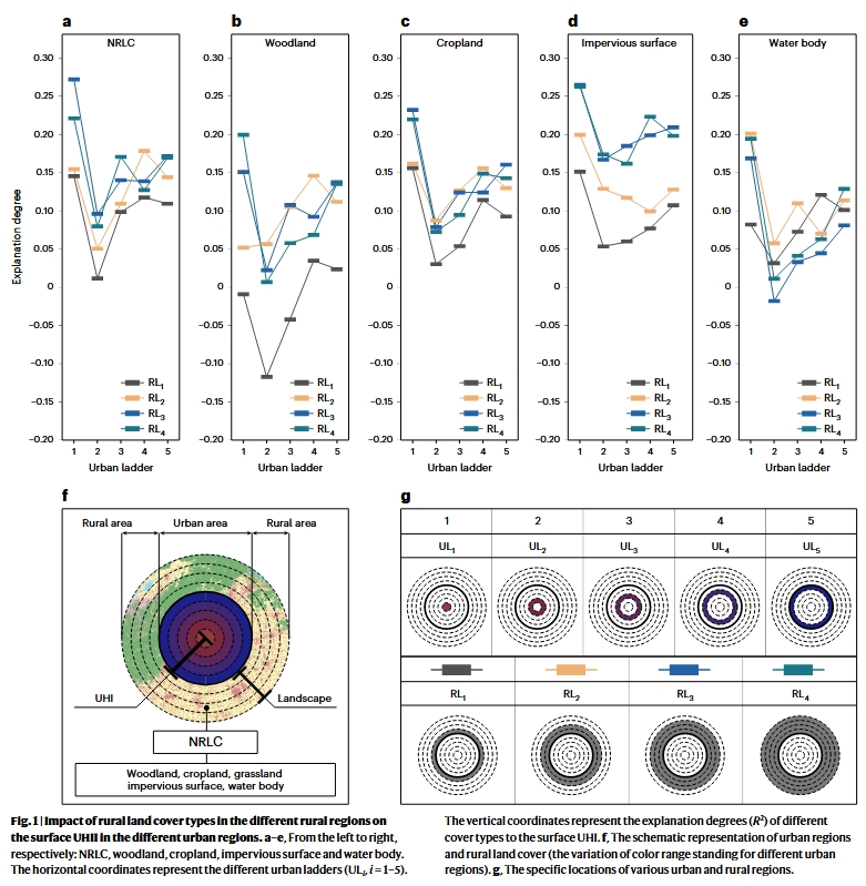
01 不同农村地区农村土地覆被类型对不同城市地区地表UHII的影响
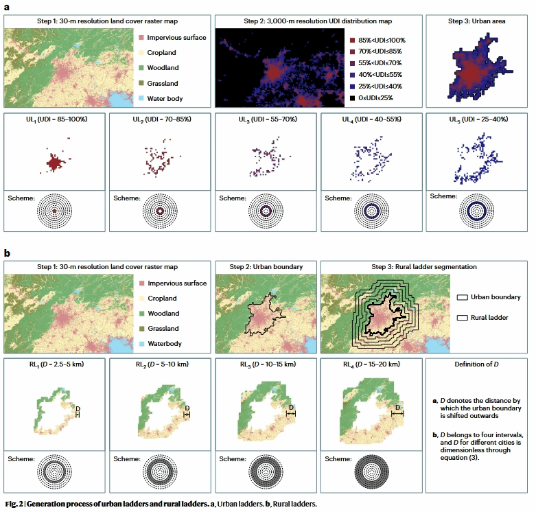
02 城市阶梯和农村阶梯的生成过程。a, 城市梯子。b、农村梯子
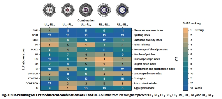
03 RL 和 UL 的不同组合的 LLP 的 SHAP 排名
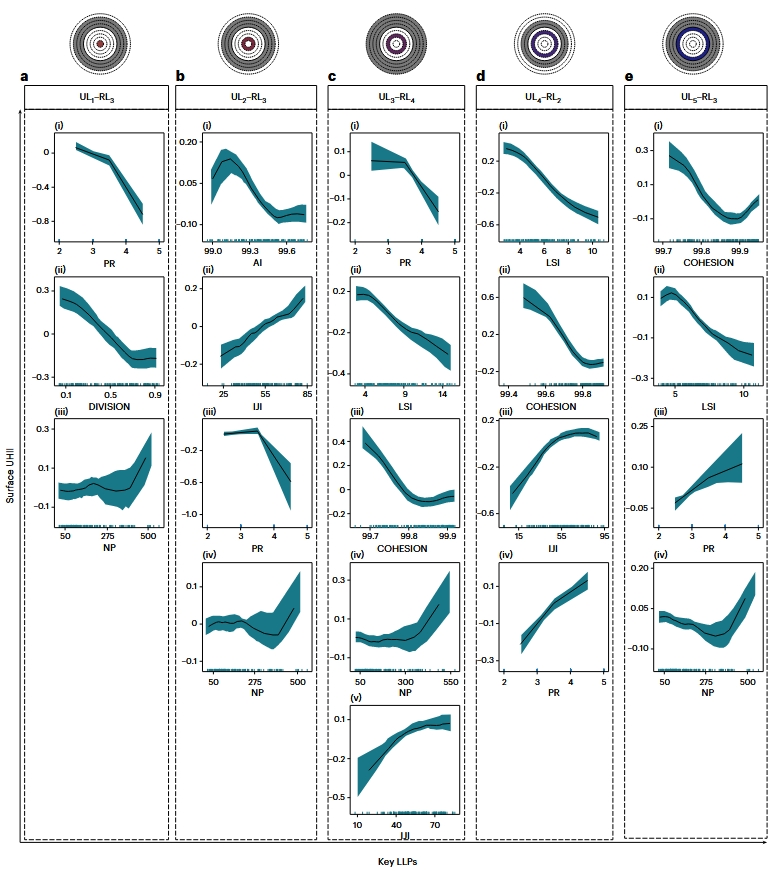
04 LLPs各关键参数对表面UHII的累积局间效应
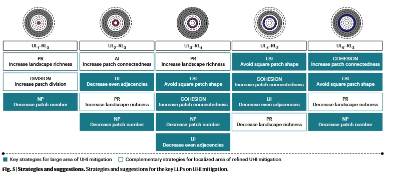
05策略和建议
原文链接:https://www.nature.com/articles/s44284-024-00091-z
原文转引:https://mp.weixin.qq.com/s/YRntBYpLXyRWgNH3vBKi_g