文章信息:Meng Ding,Peirong Lin,Shang Gao,Jida Wang,Zhenzhong Zeng,KaihaoZheng,XudongZhou,Dai Yamazaki,Yige Gao&Yu Liu.Reversal of the levee effect towards sustainable floodplain management. NatureSustainability:6, 1578–1586. https://doi.org/10.1038/s41893-023-01202-9.
整理人:杨文,2023级硕士生
整理时间:2024年6月6日
Abstract:Levees constrain roaring floodwater but are blamed for reducing people’s perception of flood risks and promoting floodplain human settlements unprepared for high-consequence flood events. Yet the interplay between levee construction and floodplain development remains poorly quantified, obscuring an objective assessment of human–water relations. Here, to quantitatively assess how floodplain urban expansion is linked to levee construction, we develop a multiscale composite analysis framework leveraging a national levee database and decades of annual land-cover maps. We find that in the contiguous United States, levee construction is associated with a 62% acceleration in floodplain urban expansion, outpacing that of the county (29%), highlighting a clear change in risk perception after levees are built. Regions historically lacking strong momentum for population growth while experiencing frequent floods tend to rely more strongly on levees and we suggest these areas to develop a more diversified portfolio to cope with floods. Temporally, the positive levee effect is found to have weakened and then reversed since the late 1970s, reflecting the role of legislative regulations to suppress floodplain urban expansion. Our quantitative framework sheds light on how structural and non-structural measures jointly influence floodplain urban growth patterns. It also provides a viable framework to objectively assess the floodplain management strategies currently in place, which may provide useful guidance for managing flood risks towards sustainable development goals.
摘要:堤防限制了咆哮的洪水,但被指责降低了人们对洪水风险的认知,并促进了洪泛平原人类住区对高后果洪水事件毫无准备。然而,堤坝建设和泛滥平原开发之间的相互作用仍然难以量化,模糊了对人与水关系的客观评估。在这里,为了定量评估洪泛平原城市扩张与堤防建设的关系,我们利用国家堤防数据库和数十年的年度土地覆盖图开发了一个多尺度综合分析框架。我们发现,在毗邻的美国,防洪堤建设与泛滥平原城市扩张加速62%有关,超过了该县(29%),这突出了防洪堤建设后风险感知的明显变化。在经历频繁洪水的同时,历史上缺乏强劲人口增长势头的地区往往更依赖防洪堤,我们建议这些地区开发更多元化的投资组合来应对洪水。从时间上看,自20世纪70年代末以来,积极的堤坝效应已经减弱,然后又发生了逆转,这反映了立法法规在抑制泛滥平原城市扩张方面的作用。我们的定量框架揭示了结构性和非结构性措施如何共同影响洪泛平原城市增长模式。它还提供了一个可行的框架来客观评估目前实施的泛滥平原管理战略,这可能为管理洪水风险以实现可持续发展目标提供有用的指导。

图 LE的综合分析,集中在毗邻的美国
a、LE的概念图。b、 四个选定地点的卫星图像暗示了洪泛平原内的城市发展(从左至右:宾夕法尼亚州拉克斯维尔;肯塔基州路易斯维尔;加利福尼亚州奇科;新墨西哥州阿尔伯克基)。c、d,防洪堤保护的泛滥平原(Up,c)和各县(Uc,d)的城市面积(103 km2)的综合分析。X轴将城市扩张时间序列划分为筑堤年T0前后的年份,其中将美国所有筑堤位置相加进行综合分析;k表示线性城市扩张率。背景世界图像地图来源:Esri、Maxer、GeoEye、Earthstar Geographics、CNES/空中客车DS、USDA、USGS、AeroGRID、IGN和GIS用户社区。

图 LE的空间模式
a、 流域(HUC2,a)和州一级(b)的LE(e)。c、 堤防建设后有限城市扩张的示例案例(位置1-4,在a中标记为绿色方块)。d、 相反的情况(位置5-8,在a中标记为绿色三角形)。在c和d中,左图显示了大堤所在的县和邻近的河流;右图显示了T0−10和T0+10的城市变化(红色表示新增的城市面积)。a和b中的圆圈表示防洪堤保护的泛滥平原的总面积;面积越大,城市扩展曲线越平滑,这对于空间复合分析的有效性来说是有效的。NA表示缺乏堤防竣工年份或足够的计算数据。在1号和2号地点,修建了防洪堤以保护当地农业区;在3号和4号位置,防洪堤建造之前,泛滥平原已经完全城市化。由于可修改的面积单元问题和堤防的分散分布,预计a和b之间不一致是合理的;在这里,我们更多地关注解释结果的突出一致性。

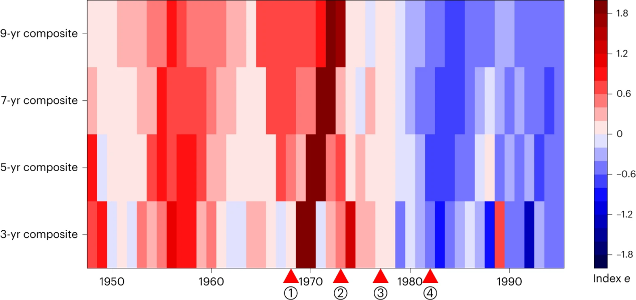
图 LE的时间动力学。
X轴显示感兴趣的年份,Y轴显示对同一年份建造的堤坝的不同位置进行分组的分析。3年、5年、7年和9年的综合指的是在综合分析中考虑以感兴趣年份为中心的年份。三角形标志着主要立法泛滥平原管理政策实施的年份;从1到4:1968年的NFIP;1973年《洪水灾害保护法》;1977年第11988号行政命令:洪泛平原管理;以及1982年NFIP的大堤政策。

图 说明防洪堤在洪水风险管理中的作用的概念图。
数字1、2和3表示LE与洪水风险的三个决定因素的联系:危害、暴露和脆弱性和“−”分别表示正/负相关性
原文链接:https://www.nature.com/articles/s41893-023-01202-9#Fig1
节选转引:https://mp.weixin.qq.com/s/7yRjaUitTsFdh1kec--OAQ