文章信息:B. Tellman, J. A. Sullivan, C. Kuhn, A. J. Kettner, C. S. Doyle, G. R. Brakenridge, T. A. Erickson, & D. A. Slayback. (2021). Satellite imaging reveals increased proportion of population exposed to floods. Nature: 596(7870), 80–86. https://doi.org/10.1038/s41586-021-03695-w
整理人:杨文,2023级硕士生
整理时间:2024年8月20日
Abstract: Flooding affects more people than any other environmental hazard and hinders sustainable development1,2. Investing in flood adaptation strategies may reduce the loss of life and livelihood caused by floods3. Where and how floods occur and who is exposed are changing as a result of rapid urbanization4, flood mitigation infrastructure5and increasing settlements in floodplains6. Previous estimates of the global flood-exposed population have been limited by a lack of observational data, relying instead on models, which have high uncertainty3,7,8,9,10,11. Here we use daily satellite imagery at 250-metre resolution to estimate flood extent and population exposure for 913 large flood events from 2000 to 2018. We determine a total inundation area of 2.23 million square kilometres, with 255–290 million people directly affected by floods. We estimate that the total population in locations with satellite-observed inundation grew by 58–86 million from 2000 to 2015. This represents an increase of 20 to 24 per cent in the proportion of the global population exposed to floods, ten times higher than previous estimates7. Climate change projections for 2030 indicate that the proportion of the population exposed to floods will increase further. The high spatial and temporal resolution of the satellite observations will improve our understanding of where floods are changing and how best to adapt. The global flood database generated from these observations will help to improve vulnerability assessments, the accuracy of global and local flood models, the efficacy of adaptation interventions and our understanding of the interactions between landcover change, climate and floods.
摘要:洪水影响的人数超过了任何其他环境灾害,并阻碍了可持续发展。投资于洪水适应策略可能会减少洪水造成的生命和生计损失。由于快速城市化、洪水缓解基础设施的建设以及洪泛区定居点的增加,洪水发生的地点、方式以及受影响人群的情况正在发生变化。此前对全球洪水暴露人口的估计由于缺乏观测数据而受到限制,通常依赖于具有高不确定性的模型。在此研究中,我们使用250米分辨率的每日卫星图像,对2000年至2018年期间的913次大型洪水事件的洪水范围和人口暴露情况进行了估算。我们确定了223万平方公里的总淹没面积,约2.55亿至2.9亿人直接受到洪水影响。我们估计,从2000年到2015年,卫星观测到淹没地点的总人口增长了5800万至8600万,这意味着全球暴露于洪水的人口比例增加了20%至24%,是之前估计的十倍。2030年的气候变化预测表明,暴露于洪水的人口比例将进一步增加。卫星观测的高空间和时间分辨率将有助于我们更好地理解洪水变化的地点及如何最佳地进行适应。这些观测生成的全球洪水数据库将有助于提高脆弱性评估、全球和地方洪水模型的准确性、适应性干预措施的有效性,以及我们对土地覆盖变化、气候和洪水相互作用的理解。
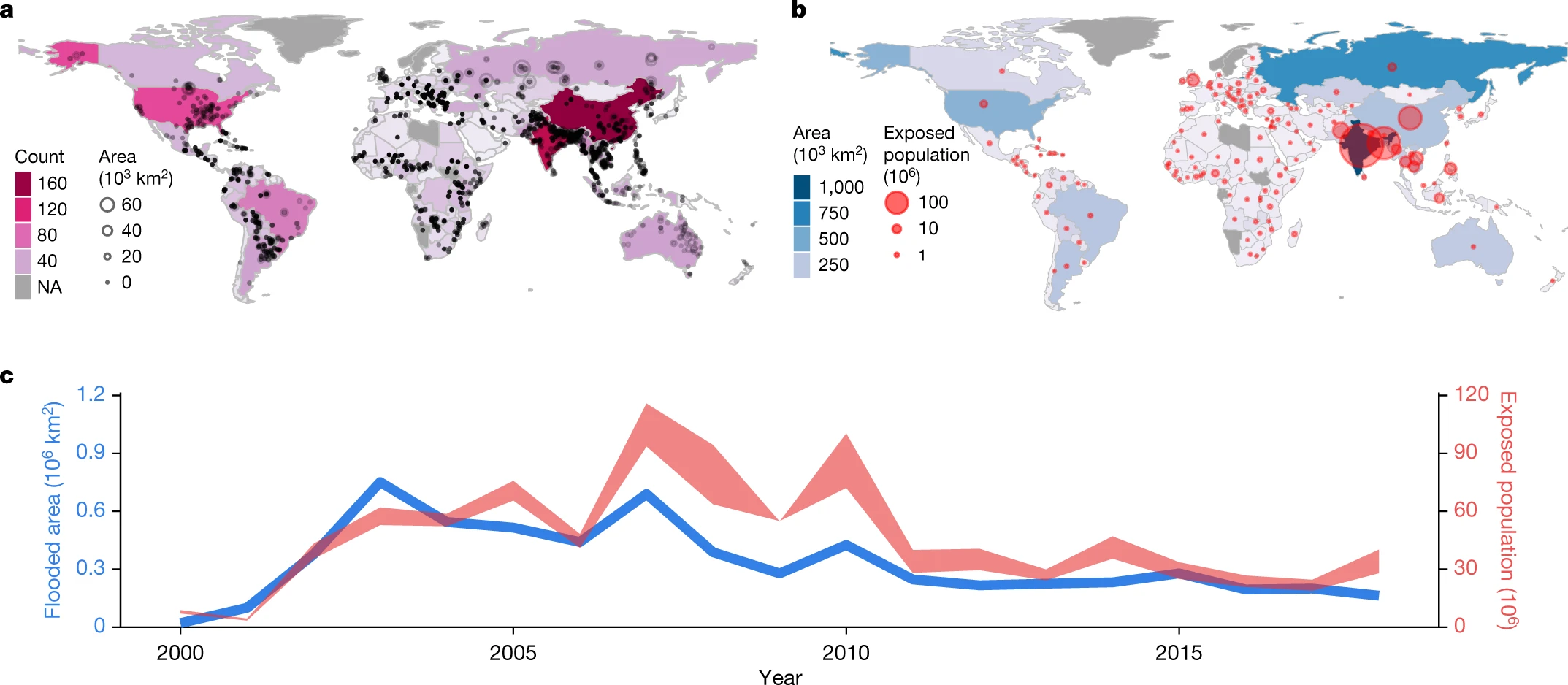
图 全球洪水数据库的汇总统计数据。 a,每个国家的全球洪水数据库中的洪水事件数量(颜色比例),以及每个洪水事件的质心位置和面积(圆圈)。没有观察结果的国家/地区呈灰色阴影(NA,不可用)。 b,每个国家的总暴露人口(圆圈)和暴露面积(色标)(2000-2015 年累计)。 c,全球年度人口估计(右轴,红色阴影;上限,GHSL;下限,HRSL)和淹没面积(左轴,蓝线)。在第二颗卫星 (MODIS Aqua) 发射之前,2000 年和 2001 年遭受洪水影响的人口和面积较低,从而增加了绘制洪水地图的可能性。

图 观测选定极端事件的洪水和洪水持续时间。 a、b,全球洪水数据库中死亡率最高的事件(a;2008 年缅甸纳尔吉斯气旋;大约 100,000 人)和恢复成本最高的事件(b)观测到的超过永久水量的洪水(来自联合研究计划25) ;美国卡特里娜飓风,2005 年;600 亿美元)。 c、d,全球洪水数据库中估计暴露程度最高(c;印度和孟加拉国,2004 年;2700 万人暴露)和面积最大(d;俄罗斯,2003 年;98,000 平方公里)的事件的洪水持续时间超过永久水)。
原文链接:https://www.nature.com/articles/s41586-021-03695-w
节选转引:https://mp.weixin.qq.com/s/MifoYn9-LOE7MXMWQVLx_A
